
Like many Americans, I grew up reading Mark Twain’s stories about Tom Sawyer and Huck Finn. The Mississippi River figures prominently in these novels, and it has always been a comforting presence in my life. To me, the river embodies infinite strength and calm, the backbone of a nation that, in the words of Winston Churchill, “can always be trusted to do the right thing, once all other possibilities have been exhausted.”
I have canoed across with my boys when they were little, exploring the islands and inlets that meander like childlike scribbles along this majestic waterway. I have helped the Sierra Club remove litter and debris from its muddy banks.
“M-I-double S-I-double S-I-P-P-I” goes the Okee Dokee Brothers song “Mr & Mrs. Sippy.” The name is taken from the Ojibwa word meaning “great river,” and the Mississippi is also referred to as Old Man River or Father of Waters.

Minneapolis
The headwaters of the Mississippi are Lake Itasca in northern Minnesota. River navigation is initiated at the Upper St. Anthony Falls Lock and Dam in Minneapolis. My son Caleb moved to the Twin Cities after graduating from St. Olaf College in 2021. Once, when we were visiting, he showed us his favorite reading spot on a bench in Water Power Park. The park is nestled into the downtown area beneath the Stone Arch Bridge, a converted railroad bridge with a panoramic view of the falls, which have been the source of hydroelectric power for flour mills since the late 19th century, like the Pillsbury plant that still exists today.
I could feel the river’s raw vigor and optimism here as it heads out the door from its place of origin with the world of possibilities awaiting. I like to think of Caleb sitting by the water, his head in a good book.
When I was growing up, the Mullenneauxs were told that we had French ancestry, a natural assumption due to the unusual spelling of our name. The loose translation was “the water that ran by the mill.” Later, with the help of research on sites like Ancestry.com, we found out that our ancestors hailed from Scotland, on the Isle of Mull. No French connection can be located going back over 500 years, so the spelling of our name is a mystery. Typically, settlers from Europe dropped letters from their ethnic surnames when they reached America in an effort to blend in. Perhaps some Scottish Mullens decided to add some extra vowels to make themselves seem more sophisticated. We’ve always liked reinventing ourselves.

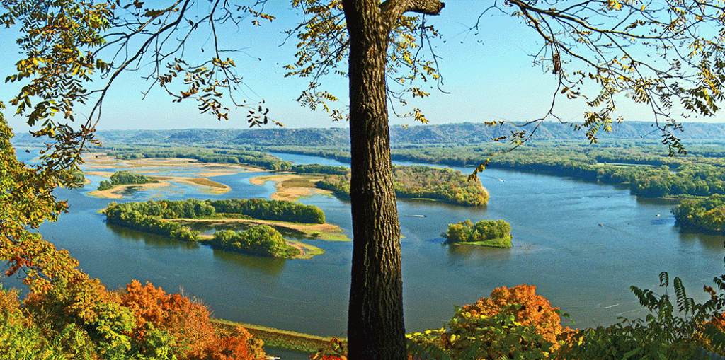
Effigy Mounds
Effigy Mounds National Monument is one of Iowa’s two national parks (the other is the Herbert Hoover Presidential Library just east of Iowa City). The park preserves 200 burial mounds built by several Native American tribes. Numerous effigy mounds are shaped like animals, including bears and birds.
My wife and daughter and I traveled to the Effigy Mounds with some friends for a weekend of camping in this cozy Northwestern corner of Iowa. We visited scenic Yellow River State Forest and canoed through limestone cliffs along the Upper Iowa River. When we arrived at the park’s gift store, I picked up a copy of naturalist Terry Tempest Williams’s book The Hour of Our Land.
“Some 1,500 years ago, these earth mounds were made by the hands of the people who lived here in the Upper Mississippi Valley, ancestors to today’s Ho-Chunk people, also known as the Winnebago,” Williams writes. “This is the ‘Driftless Area,’ where the glacial sheets of ice that stretched across the North American continent during the Pleistocene fell short of this holy site. A Ho-Chunk woman would see these figures through the gestures of ceremony: the burying of the dead; the honoring of birds and bears. As a visitor, I experience this land as a walking meditation.”
When we hiked up the trail, I experienced firsthand this deep silence and the reverence it inspires for this ancient land. The mounds themselves aren’t that impressive to the naked eye, more like overgrown grassy hillocks. At the top of the trail, we emerged at an overlook with a glorious view of the Mississippi River. We peered down at the Canadian Pacific Kansas City line as it wound along the banks of Marquette, Iowa, looking like a model electric train maneuvering through toy houses. Gazing across the river, we could see Prairie Du Chien, Wisconsin, and northern Illinois.
Davenport
On Interstate 80, the grand thoroughfare that traverses the middle of the U.S. from New Jersey to San Francisco, we crossed the Mississippi River into Davenport. Since we often head back through Davenport to Iowa after vising our oldest son, Avery, in Chicago, I associate this town with coming home and the jumble of emotions that brings.
Designated in 1956 as part of President Eisenhower’s national highway system, I-80 first opened in Iowa a couple of years later near Des Moines. The bridge of the river, now known as the Fred Schwengel Memorial Bridge, was built in 1966. In the final segment of his Pulitzer Prize-winning book Annals of the Former World, John McPhee writes:
“Near Davenport, in Iowa, you stop to photograph a small farm, its barn like a biscuit on a summit of a loaf of bread. Under the hay and windmills of Iowa is large groundswell chocolate land, glaciated terrain and nothing flat about it. And a wind that sounds like whitewater as it moves through isolated stands of trees.”
Whipping in from the west, the wind whispers adventurous tales to travelers crossing the river here, of surfing Pacific Ocean waves, soaring across the Grand Canyon, and crossing the Continental Divide over the Rocky Mountains.

Burlington
Like so many river towns, Burlington’s best days may be in the distant past, but the city is definitely trying. Downtown revitalization efforts are continually stalling and restarting. The beloved Burlington Bees lost their minor league affiliation when Major League Baseball restructured in 2018, and now play semi-pro ball to groups of diehard fans on summer nights at Community Field.
Next to downtown Burlington, a riverwalk curls beneath the Highway 34 bridge from the Memorial Auditorium to a marina. Majestic homes perched on the cliffs above used to have a million dollar view, but these days probably go for about half that.
Crapo Park, a vast network of playgrounds, trails, and ball fields, is reputed to be the site where the American flag was first raised on Iowa’s soil by explorer Zebulon Pike in 1805. Where the park meets the river, there is a band shell, a replica log cabin, and a pair of vintage anti-aircraft guns on a beautiful bluff.
We were lucky to be there one summer evening when the Municipal Band was playing, and we sat on a bench listening to old standards, followed by a fireworks display. A path drops down beneath the bluff overlooking the river and the railroad tracks. My daughter, Caroline, asked why a steel guard rail was blocking off the trail. Erosion had worn away the path to the point where it was deemed unsafe by the Parks Department, but we forged ahead, ducking under the fence. We’d been walking this trail since she was a baby to Black Hawk Cave, where you can crawl back more than 100 feet towards a natural spring. Chief Black Hawk and his Sauk tribe used to camp nearby. We kicked off our shoes and waded in the spring, where the water was cool on our bare feet as we explored the cave. Water trickled down the mossy waterfall, below the tracks, and out to the banks of the Mississippi, merging with the current, heading for the Delta.

Hannibal
On spring break, we headed down to St. Louis, with a pit stop in Hannibal, where Mark Twain grew up Samuel Clemens. Two local caves became the setting for many of the adventures he would write about. Having already seen the official Mark Twain Cave, we opted to check out the newer Cameron Cave down the road for more of an authentic spelunking experience.
Cameron Cave has been left in its natural state since its discovery 100 years ago. As we entered the cramped, unlit cave with flashlights, my claustrophobia kicked in and I had a moment of panic. I handled my anxiety by staying focused on our guides, a couple of young men who had memorized the route using natural markers called the Teapot and Buttermilk Falls. Each name is inspired by the shape of a rock formation, a stalagmite, or the story of some explorers who traversed these stone paths before us.
It is safe to say that Hannibal has fully embraced its literary native son and includes him in their local business branding whenever possible. In addition to the caves, there is Becky Thatcher’s Diner, the Huck Finn Shopping Mall, and his boyhood home, which you can tour. At the Mark Twain Dinette, they make their own root beer. I washed down a fried catfish sandwich with some, and I must admit it was delicious.
Looking out on the Mississippi River these days, you are much less likely to see the steamboats of Mark Twain’s youth. Along with more than one and a half million metric tons of nitrogen per year from agricultural runoff, what’s mostly flowing down river are barges. These flat-bottomed vessels are towed or pushed by tugboats creeping slowly along, their motion barely detectable. The typical barge is half as big as a football field and can carry 1,500 tons of cargo. According to a study from the Transportation Institute at Texas A&M, transporting cargo by barge produces 43 percent less greenhouse gas emissions than rail and 800 percent less than trucks.
Traveling at an average speed of 8 mph, a barge leaving the Port of Minneapolis bound for the Gulf of Mexico reaches New Orleans in about three weeks. These gargantuan vessels have a relatively small crew, usually just a captain, engineer, a cook and other deckhands. They might transport grains and other commodities, coal, or construction materials.

St. Louis
St. Louis marks the halfway point for the big river, and the end of the Upper Mississippi. My mother’s hometown. I have now reached middle age, and wonder what I want for this, my second half. Much of these days I feel I am drowning in the river of life, weighed down by the pressures of everyday living, while reconciling and learning from past mistakes and desperately trying to mold my remaining hopes and dreams into realistic, actionable plans for the future.
When we visited St. Louis in late March, spring was already springing. Just the sight of green grass and budding blossoms awakened joy in my heart. At Shaw’s Nature Preserve, near my Uncle Mark’s cabin in Robertsville, rows of sunny yellow daffodils and bluebells greeted us. We visited the Missouri Botanical Garden’s Japanese Garden, and strolled across the lake and its islands to see the cherry trees beginning to bloom.
It Just Keeps Rolling . . .
The Mississippi River has been here a long time before us. It will be here a long time after we’re gone. Whatever your troubles and concerns, I think that Ol’ Man River knows and understands. Knowing and still going, slowly, gradually along. With the flow.