
Tehachapi, CA: I look out my hotel window and see two inches of snow and the low gray clouds of a late winter storm and decide it's time to visit Death Valley where I can pretty much guarantee it will be 85 degrees or more.
Death Valley is a deep cleft in the landscape on the eastern edge of the Mohave Desert, 250 miles or so inland from the Pacific Ocean. It contains the lowest land in North America and some of the continent's most quintessential desert landscapes. Summer temperatures often reach 120 degrees and rarely fall below 100 degrees. Water can evaporate from the valley floor at a rate of 150 inches per year. It's not the kind of place you would want to find yourself on a horse with a single canteen of water, which of course is how the valley got its name. The 1849 California gold rush tempted a series of intrepid wagon trains to seek a short cut through the valley. Only one wagon made it through. As the survivors left the superheated landscape, a member of the party turned and quipped, "Goodbye Death Valley", and the name stuck. To the Timbisha Shoshone whose people have made it their home for over 500 years, however, it is their "valley of life."
It's a place I've always wanted to visit.
I approach from the western edge of the park, turning off highway 395 as it passes north through Owens Valley and heading east on highway 190. There is still a chill in the air and snow clouds hang like gas over the eastern edge of the Sierra Nevada mountains. 190 is a roller coaster of a ride, taking you first up to 5,000 feet, then down into Panamint Valley, a kind of preview of Death Valley itself-dry, dusty and isolated, but with the fierce beauty that only deserts can provide. Then it's back up to 5,000 over Towne Pass before the precipitous descent into Death Valley, itself. The valley floor appears in a series of brief cameos as you wind down the mountain road. From a distant soft white clouds floating in a blue sky mix with ochre desert sandstorms, set against sharp ridge edges and curving rock patterns woven in burnt umber, violet and pink.
By the time I reach Stovepipe Village, the winter cold is definitely behind me. Temperatures are hitting the 80's and the winds are blowing strong and dry as I step out of my car to pay the park entrance fee. The air smells of sand and roots. To the north of the ranger station the Mesquite Flat Sand Dunes fold into the distance. Part of the first Starwars movie was filmed here. When I look at the visitor's guide I notice Zibriskie Point is 30 miles down the road, the source of the title for the seminal 60's movie by Italian director, Michelangelo Antonioni, about alternate states of reality with music by Pink Floyd (who else?) and one of the best explosion scenes ever filmed. I'm in a movie induced nostalgia mode- the film came out in 1970 just as I was embarking on my own journey of self-discovery-and it stirs in me a reflective sense of peace.

After a quick lunch, I decide my first call has to be a pilgrimage to Zibriskie Point. On the drive over I notice a thin gauze of tiny yellow spring flowers is spread like a carpet across the dusty desert floor. The Point is located on the other side of the Furnace Creek Visitor Center (190 feet below sea level), a surprising oasis of green leaves and palm trees amongst the quivering heat waves, and has a stone-edged observation platform in order to view the jagged yellow borax-laden hills that surround it. I can't remember if any of the film was actually shot here (I suspect the Mesquite Flat sand Dunes were used for the naughty sex scenes) but visiting the site almost exactly forty years after I first watched the film somehow completes a circle of experience.
Pilgrimage over I head south on highway 171, to seek out one of the main purposes of my visit. I've always had this sneaking desire to stand alone in the middle of a flat desert landscape and I suspect I might be able to do so in the Badwater Basin (the lowest elevation in the U.S. at 282 feet below sea level). As I head down the freshly paved blacktop, the white salt flats that form the basin shimmer in the distance, and the place names get wilder (ie. Devil's Golf Course). Parking my car, I head out onto the dry salt lake. Temperatures are hitting the 90's, but nowhere near the heights they will reach in the summer months. Other visitors are walking with me but after a quarter of a mile or so they fall behind and soon I am on my own, striding across a sea of solid salt, which squeaks mischievously with every step as if alive. Further out, the surface comprises a series platelets welded together like giant white omelets. When I break off a number of salt nodules, each one has a small brown center of mud like a chocolate-filled confection. Pushing my fingers below the surface makes water leak out. It's hard to know if I am standing on ice, water, sand or salt.
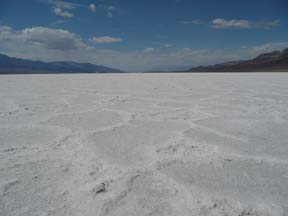
After walking for about 20 minutes, I stop and look back. The nearest person is a minute tick in the distance and flickering like a mirage. There is nothing but unending white space all around. The wind drops and a resounding silence settles over me with a sweet heaviness. The experience is all I had thought it would be. I feel I've reached some inner home.
On the way back to the shore, I take off my shoes and let the salt soak into my feet. The sharpness of the ice crystals punctuates the expansiveness of the moment. Incongruously, everyone I meet on the way back is speaking German, making the experience of the afternoon even more surreal.
As the sun drops down in the sky, I leave the valley via Jubilee Pass for the long drive back to Tehachapi. A brief shower leaves the air smelling of sage and damp earth. As I drive, I consider searching out a copy of Zibriskie Point on the internet when I get back to my hotel but decide against it. Sometimes the mellow haze of memory is best left undisturbed.